
Due to its position in the Lea Valley, Stanstead Abbotts has relatively abundant water resources many of which are available for a variety of leisure purposes. The main water course is the River Lea and there are numerous lakes throughout the area. The majority of these have formed by the natural flooding of worked out gravel pits. Gravel extraction has taken place in the area for decades but in the last twenty years or so the shorelines of some spent pits have been skilfully terraced to create environments that encourage wading birds and other wildlife.
Stanstead Abbotts indicative floodplain
A negative
aspect of all the local water is the potential for local flooding.
Flooding has become a reality for many in the UK in recent years. To
help householders and businesses assess their personal risk form
flooding The Environmental Agency (EA) has identified the potential
area of flooding for all UK rivers if they were overwhelmed by excess
water. The map shown is based on the one issued by the  agency
and shows the indicative floodplain for the Stanstead Abbotts area.
This shows the theoretical area under threat if the River Lea were to
overflow. Flooding of the High Street was a relatively common
occurrence until to the 1960's but in recent years the river level has
been successfully kept under control by the Lea
Flood Relief Channel. Realistically the
Environmental Agency points out any flood control measures can only
reduce the risk, never completely remove it.
agency
and shows the indicative floodplain for the Stanstead Abbotts area.
This shows the theoretical area under threat if the River Lea were to
overflow. Flooding of the High Street was a relatively common
occurrence until to the 1960's but in recent years the river level has
been successfully kept under control by the Lea
Flood Relief Channel. Realistically the
Environmental Agency points out any flood control measures can only
reduce the risk, never completely remove it.
Despite the high rainfall
during the winter of 2000/2001, the wettest since official records
began, relatively few problems were experienced locally. This is more
than can be said of many other water catchment areas around the UK who
have suffered badly. However, one day of very heavy rainfall in mid
October 2001 resulted in the river overflowing the towpaths near the
High Street. It was stated during a conference at The Science Museum
recently (2002) that existing flood defences built to withstand a 1 in
100 year storm will by the year 2050 only be sufficient to deal with a
1 in 25 year storm. If the predictions that climate change will
increase our rainfall are correct then additional investment will be
necessary to keep the river in check.
The homes
on recent housing developments close to the River Lea have been built
substantially above the existing high water level so they should be OK
for a decade or so. However, the wisdom of allowing new homes to be
built close to rivers is increasingly coming into question. It is
undeniable that riverside locations are attractive but the potential
risk of flooding is the downside of having a picturesque view of water
on your doorstep (although not too literally, one hopes).
The New River is not liable to flooding as it is a man made aqueduct with negligible surface water draining into it. The banks of the New River are at a higher level than the Lea so at Stanstead Abbotts it forms an effective western flood barrier to the Lea as can be seen on the map.
While perhaps bearing little comparison in size to greater British rivers such as The Trent, Severn, Thames and the like, the River Lea is the biggest river in Hertfordshire. Its source is near Leagrave Marsh in the northwest outskirts of Luton in Bedfordshire. From there it meanders vaguely southeast until it reaches Ware. It then travels almost due south to London where it discharges into the River Thames at Canning Town directly across the water from Greenwich and the Millennium Dome. Its largest tributary, the River Stort, joins the Lea near Hoddesdon from where it is navigable as far as Bishops Stortford.
 The
Lea is believed to have been navigable as far as Hertford way back in
Roman times although this may have been with some difficulty. The
Vikings used it to reach Ware no doubt plundering and pillaging other
towns on the way. It is said that bodies from the Great Plague of
London were moved on the Lea for burial in The Great pit at Ware. For
centuries each district through which it passed dealt with the river in
the way it saw fit leading to variable standards of navigability. The
Lea Navigation Act of 1739 was passed with the intention of ensuring
that the entire length of river was treated in a consistent manner.
Following this Act a unified approach was applied which led to the
river being dredged throughout its length and locks installed locally
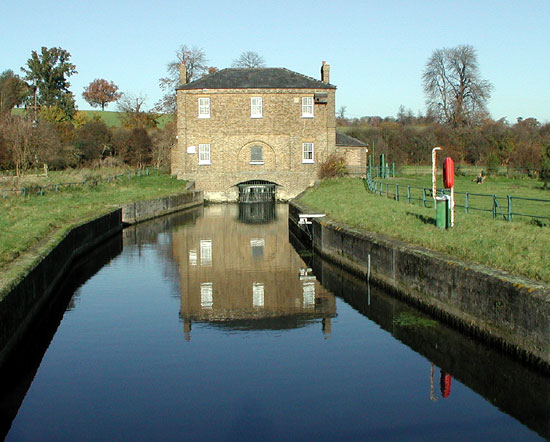
at Stanstead Abbotts, Ware and Broxbourne.
The
Lea is believed to have been navigable as far as Hertford way back in
Roman times although this may have been with some difficulty. The
Vikings used it to reach Ware no doubt plundering and pillaging other
towns on the way. It is said that bodies from the Great Plague of
London were moved on the Lea for burial in The Great pit at Ware. For
centuries each district through which it passed dealt with the river in
the way it saw fit leading to variable standards of navigability. The
Lea Navigation Act of 1739 was passed with the intention of ensuring
that the entire length of river was treated in a consistent manner.
Following this Act a unified approach was applied which led to the
river being dredged throughout its length and locks installed locally
at Stanstead Abbotts, Ware and Broxbourne.
John
Smeaton, the first
engineer to be called a 'civil engineer', was employed on the river in
1765 to undertake the task of installing
additional locks, creating significant new cuts to make the Lea more
navigable and forming a continuous towpath. In time he was followed by
another great engineer, Thomas Telford,
famous for his work on bridges and canals, who carried out yet further
improvements to the Lea. This work helped make the river what it is
today, a mixture of modified natural watercourse and man made
navigation canal sections. In other words, a canalised river.
to undertake the task of installing
additional locks, creating significant new cuts to make the Lea more
navigable and forming a continuous towpath. In time he was followed by
another great engineer, Thomas Telford,
famous for his work on bridges and canals, who carried out yet further
improvements to the Lea. This work helped make the river what it is
today, a mixture of modified natural watercourse and man made
navigation canal sections. In other words, a canalised river.
The Hertford Union Canal, perhaps confusingly situated in London not Hertford, was completed and opened in 1830. This linked the Lea to the Regents Canal and bought navigable access through to the Grand Union Canal system. Further major work was carried out during World War I to allow 100-ton vessels to navigate as far as Hertford. Later, during the 1920’s the locks between Hertford and Enfield were completely reconstructed.
During the 20th century flooding was becoming more frequent along the Lea Valley. On a purely local perspective Stanstead Abbotts and Ware often suffered flooding. Until a few years ago The Jolly Fisherman pub in Stanstead Abbotts had a flood level gauge on the outside wall and the more significant flood levels were marked next to it. This may have disappeared to make the new residents on the new riverside developments feel less nervous! One of the major causes of this flooding was the gravel extraction that had taken place throughout the valley. For many thousands of years water draining into the valley had not only drained into the river channel but had also into the subterranean gravel beds. In effect the water drained from the valley as it percolated through the gravel beds as a vast subterranean river. The abstraction of gravel closed off much of this underground river forcing the river channel to carry more water than it could contain under flood conditions.
Work began in the 1930’s to create a flood relief channel but the final improvements that finally resolved the continued flooding were not completed until the early 1970’s. These involved widening the channel and dredging the river bottom deeper to increase its capacity and installing a series of automatic sluice gates. These gates control the flow through the relief channel which links together many of the redundant gravel pits.Since the completion of this project flooding at Stanstead Abbotts no longer seems to be a problem, even during the 2000/1 winter when rainfall levels exceeded all previous records. However indications suggest that climate patterns may be changing for the worse and wet seasons may become more common. If this is the case then further investment may be needed to ensure the Lea Flood Relief Channel is able to cope in years to come.
History
 The New River is
technically not a river but a entirely man made aqueduct. At the end of
the 16th century the population of London was increasing and the lack
of fresh water was leading to serious health problems. Edmund Colthurst
had a plan to bring fresh water from Hertfordshire but although there
were surveyors and engineers with the necessary skills a number of
difficulties lay ahead. Despite the need for such a scheme and the
benefits it would bring to London the aqueduct only became a reality
because of the support his plan received from financier, Hugh Myddelton.
The New River is
technically not a river but a entirely man made aqueduct. At the end of
the 16th century the population of London was increasing and the lack
of fresh water was leading to serious health problems. Edmund Colthurst
had a plan to bring fresh water from Hertfordshire but although there
were surveyors and engineers with the necessary skills a number of
difficulties lay ahead. Despite the need for such a scheme and the
benefits it would bring to London the aqueduct only became a reality
because of the support his plan received from financier, Hugh Myddelton.
A direct path from source to reservoir would have been about 23 miles. The water would have to rely on gravity to flow to London and a direct route would have involved massive bridge structures and tunnelling to level out the terrain along the path. The inspired engineering solution was to accurately follow the 100-foot contour line, as far as was practical, from Ware to Clerkenwell in central London. This avoided the need for bridges and tunnels but extended the length of the original route to almost 40 miles. It was planned that throughout its entire length the river would drop only 18 feet from end to end, less than 6 inches for each mile.
The project got under way in 1605 and after some
progress had been made Colthurst sought funding from the City of London
Corporation. Regrettably, the Corporation was not willing to provide
the funds, possibly because they doubted the scheme would be a success.
The project began to falter and it was not until 1609 when Hugh
Myddelton offered to take over the scheme that work got under way in
earnest. In 1610 work slowed yet again because Myddelton encountered
difficulties with landowners who refused to have the river cross their
land.
Although Myddelton was a wealthy man by 1610 the scale of the project was becoming a serious drain on his finances. Together with the objections from landowners there was a prospect of the project not being completed. Fortunately. he finally found favour with King James 1 who promised the additional funding required in exchange for 50% of any eventual profits. The king also agreed for the river to cross the royal estate at Theobalds Park which solved some of the landowners objections.
By 1613 the aqueduct was finished and carried the first water from AmwellSpring and Chadwell Spring near Ware in Hertfordshire to the Round Pond in Islington, London. Even with the benefit of the mechanised equipment and materials we have today this 40 mile aqueduct would have been a considerable achievement. The original source at Chadwell Spring <above>, between Hertford and Ware, combined with spring water from Emma's Well at Great Amwell could not keep up with the increasing demand. In 1738 the New River company promoted a Bill in Parliament allowing them to extract a measured quantity of water from The Lea at Ware.
 A link was cut
between the two with the flow regulated by a device known as the
‘gauge’. The original wooden
‘gauge’, was upgraded in 1770 by Robert Mylne and
was enclosed in a large marble structure. Although this chest still
remains, it now stands empty <right>.
A link was cut
between the two with the flow regulated by a device known as the
‘gauge’. The original wooden
‘gauge’, was upgraded in 1770 by Robert Mylne and
was enclosed in a large marble structure. Although this chest still
remains, it now stands empty <right>.
William Chadwell Mylne, son of Robert, built the ‘New Gauge’ and the building <left> that houses it in 1856. This device is still in use today and is believed to be unique. It consists of two large boat like floats connected by steel beams. A sluice gate connected to this beam controls the flow between The Lea and The New River as the floats rise and fall with the water level. Further flow regulation is available by fitting or removing control plates.
Without the ingenuity of father and son architects/civil engineers Robert Mylne and William Chadwell Mylne the New River may have outlived its usefulness many years ago. A large part of the New River Company’s continuing success was undoubtedly due to them. It is perhaps fitting that William and Robert Mylne, and some members of their family are buried in the churchyard of St John the Baptist that overlooks the tranquil Amwell Pool on the New River <below>.

From The
Round Pond reservoir in Rosebury Avenue, Clerkenwell water had to be
distributed to premises along wooden pipes formed from hollowed out
tree trunks. This distribution again relied on gravity to get it to
consumers. In the early 18th century a new reservoir was built in
Islingtonat a higher elevation about ¼ mile along Amwell
Street. This increase in height gave more pressure enabling
distribution to a much wider area. A windmill driven pump was
originally used to move the water to the higher reservoir but in 1720
this was changed to a horse driven mill. This horse power in turn gave
way later to steam power.
To complete the New River in the timescale using manpower aided only by horses, almost four centuries ago was an extraordinary feat of engineering. To this day the river continues to supply some of Londons' water and remains a lasting testament toHugh Myddelton.
Sir
Hugh Myddelton
Hugh Myddelton (later Sir Hugh) was a successful London goldsmith who had financial interests in Welsh mining and cloth making. He was also involved in commercial ventures with Sir Walter Raleigh. Born in 1559 in Denbighshire, North Wales, he was Member of Parliament for Denbigh from 1603 to 1628 and Alderman of London.
A statue of Sir Hugh, to commemorate his great work in providing fresh water to London, stands at the junction of Upper Street and Essex Road, Islington, ½ a mile from the site of the New Pond. Many of the streets in Islington have names associated with the New River, such as Amwell Street, Chadwell Street and Myddelton Square, Passage and Road.
The New River - Today
The construction of the Thames Water Ring Main system, completed in 1992, put the future of the New River under threat as it was considered there would be no further need for the supply. However the redevelopment of London docklands put increased demands on London's water supplies and earned the New River a reprieve. Water is now piped from the New River to the Coppermills Reservoir at Walthamstow in East London which in turn serves the Docklands area. Additional boreholes have been sunk in several places to increase the capacity of The New River and its future seems assured for the foreseeable future. The river now terminates at Stoke Newington but some disused sections have been converted to recreational use.
The New River Path is a well marked walking route between Ware and the M25 motorway. A section of the old water course at Enfield was opened to the public during the Spring of 2000.
Abbotts Lake
This almost 30 acre lake sits on the eastern edge of main village. It was created from a redundant gravel pit that was flooded about thirty years ago. The lake was originally larger than it is now but the southern end was backfilled when the Stanstead Abbotts bypass was being built. The lake provides home to the Hertford County Yacht Club as well as being an angling venue for specimen Carp. The lake is owned by Lea Valley Regional Park Authority but the fishery management is by RMC Angling.
The Banjo / Nelson's Lake / Pretty Pit / Stock Pond
These four smaller angling lakes ranging between 1 and 3 acres in the south-east of the village are also managed by RMC Angling. They all hold good size Carp and between them have been stocked in recent years with Common and Mirror carp, Roach, Perch, Bream and Rudd. The Banjo is known to hold specimen carp to 29lb, while Nelson's and The Stock Pond hold specimen over 20lb.
Amwell lakes
Amwell lakes are two relatively small waters of 3 and 5 acres towards Amwell, north of the High Street between the River Lea and the Mill Stream. They provide good opportunities for anglers as they hold a fine stock of fish, particularly Carp to 30lb+.
............ see Leisure
Activities
![]()